Building on the legacy of Tesoros Escondidos en la Selva de Puerto Morelos, this collaborative project between the Maya Heritage Center and the Casa de la Cultura seeks to rediscover the shared narratives that unite the region’s Maya and colonial pasts. Supported by the Delmas Foundation, the initiative engages local residents, students, and researchers to document oral histories, archaeological sites, and community memories preserved in the landscape of Puerto Morelos.
Through workshops, exhibitions, and interpretive panels such as Monos Araña y Corcho, Mulchi, Peregrinos y Ofrendas, El Oratorio, and Coxol, participants explore how heritage, ecology, and identity intersect across centuries. The project revives ancestral knowledge of temples, trade routes, and sacred caves—creating an inclusive narrative that honors both Maya voices and the layered history of encounter and adaptation.
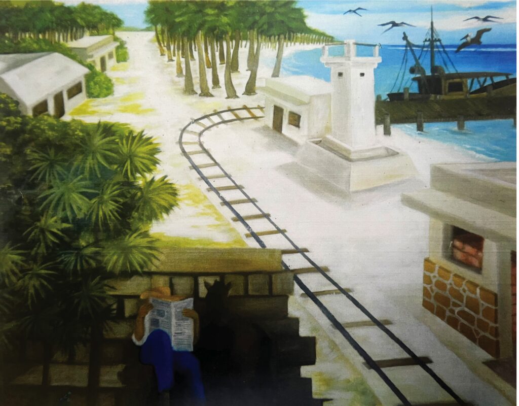
In the early 1900s, Don Manuel, a young rigger, awoke each dawn at Punta Corcho — today’s Puerto Morelos — with the salty breeze and the cry of gulls. Beside him, Doña Carmen, a natural-dye merchant, inspected the thick cedar and mahogany logs emerging from the jungle.
From that red-earth pier, zapote trunks and railroad sleepers set sail on schooners bound for distant ports. Doña Carmen, her hands stained by “dyewood” bark, spoke proudly of her pigments dressing textiles in Europe.
Each afternoon, word spread of the natural chicle harvest: the resin of the chico zapote tree, transformed into chewing gum, bolstered soldiers’ morale in World War II. Don Manuel still imagines caravels laden with sticky cargo steaming toward the Americas and Asia.
In their stories, Punta Corcho is no longer just a dot on the map; it stands as a living legacy to intertwined tales of labor, trade, and dreams that shaped the identity of Puerto Morelos.
A principios del siglo XX, Don Manuel, un joven cargador, despertaba cada amanecer en Punta Corcho–hoy Puerto Morelos–con la brisa salina y el eco de gaviotas. A su lado, Doña Carmen, comerciante de tintes naturales, revisaba las gruesas maderas de cedro y caoba que emergían de la selva.
Desde aquel muelle de tierra roja, los troncos de zapote y los durmientes para trenes emprendían su viaje en barcos de vela hasta puertos lejanos. Doña Carmen, con manos endurecidas por el tinte de “palo de tinte”, contaba orgullosa que sus colorantes vestían telas en Europa.
Cada tarde, el rumor de la extracción de chicle natural llegaba al pueblo: la resina del chico zapote, convertida en goma de mascar, alimentó la moral de los soldados en la Segunda Guerra Mundial. Don Manuel imagina todavía carabelas cargadas de kilos pegajosos rumbo a América y Asia.
En sus relatos, Punta Corcho ya no es solo un punto en el mapa: es un legado vivo de historias entrelazadas de trabajo, comercio y sueños que forjaron la identidad de Puerto Morelos.
Ka’aj óolik u t’aan tu’ux ka wa’alik te’ le’ panelo’.
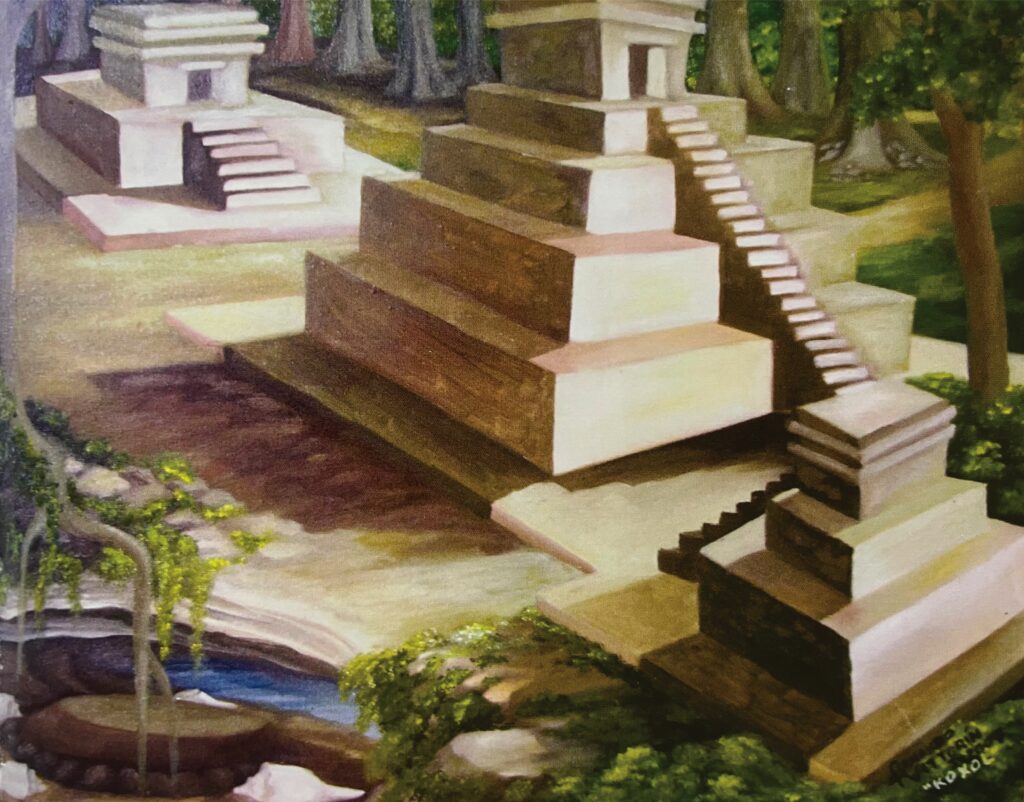
This is a site that originally was settled in Preclassic times around 2 000 years ago (350 B.C.–150 A.D.), whereas its architecture dates to the Postclassic period (1200-1500 A.D.). Its current map indicates that it was one of the largest sites in the area and theoretically responsible for the reception and transportation of goods to larger interior sites. It contains several groups of central buildings, large cave
Este es un sitio que originalmente fue ocupado desde el preclásico, es decir, hace cerca de 2 000 años (350 a.C.-150 d.C.), aunque su arquitectura es postclásica (1200-1500 d.C.). El plano actual del sitio indica que fue uno de los sitios más grandes en el área y teóricamente responsable de la recepción y transportación de bienes de consumo hacia sitios más grandes del interior. Contiene varios grupos de edificios centrales, grandes cuevas y depresiones conocidas como reholladas; se construyó en un ambiente singular silvestre manipulado por los primeros ancestros mayas.
Lela káajnalta’ab ti’le preclásico wa óoli 2,000 ja’bo’ob (350 a.C. tak 1500 d.C.) kex le bix beetaniko’obo bey ti’ le ku k’aabata’al postclásico (1200 tak 1500 a.D.). Je’el bix yanik le kúuchila ku chíikbesik jump’éel ti’ le máas nojoch yaanchajo, je’el u páajtal u ya’alal tu’ux ku k’ama’al yéetel ku bisa’al ba’ax jaantbil tu láak’ kaajo’ob. Yaan ya’ab nojoch múuch najo’ob, bey xan nojoch sajkajo’ob yéetel tu’ux ku yaantal ja’ k’ojo’ol ta’an bey jaltuno’obe, lela beeta’ab tumen le úuchben ch’ibalo’ob Maya’obo.
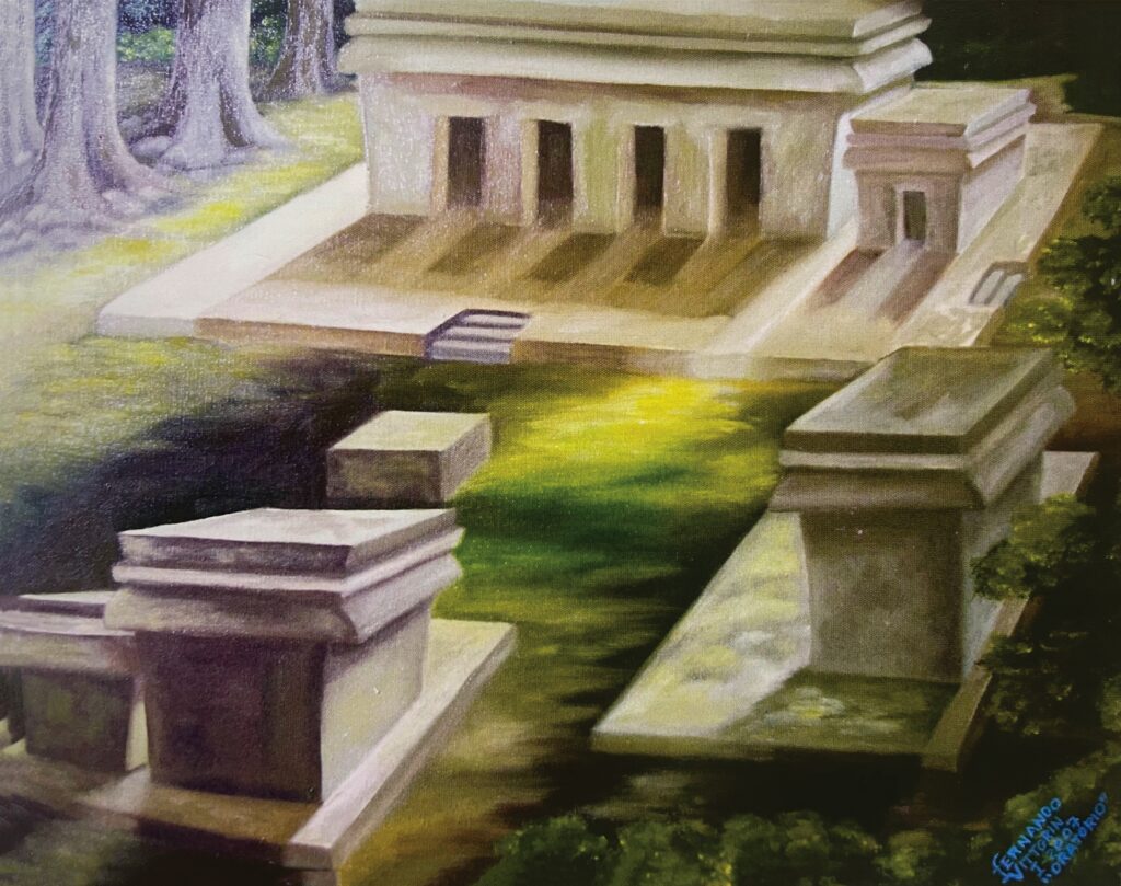
It is also a large site in relationship with its contemporary cities in time and area. This site contains two groups of temples, each forming a plaza. The architecture is oriental “coast style” dating to the Postclassic period (1200-1500 A.D.). Each group is built on a low platform conforming temples that contain small shrines. Andrews in 1980 noted an extended zone with many stone foundations that were the bases for the houses of the inhabitants of the city.
Es también un sitio grande en relación con sus contemporáneos en tiempo y área. Contiene dos grandes grupos de edificios conformando plazas. Estos templos son del estilo “costa oriental”, fueron construidos en el período postclásico (1200-1500 d.C.), sobre plataformas bajas y el interior de sus templos contiene pequeños altares. En los 80’s Andrews notó una zona extensa en los alrededores del sitio donde los habitantes construyeron las bases de sus casas hechas de piedra y de material perecedero o paja.
Bey xan jump’éel kúuchil nojoch wa k-keet ik yéetel u maasil yaan te k’iino’ob káachilo’. Yaan káap’éel nojoch múuch’ najo’ob ku beetik u yaantal k’íiwiko’ob. Te k’ulnaj bey ye’ex le ku beetal te láak’inoj, beetabo’ob tu k’iinilo’ob postclásico (1200-1500 d.C.), yóok’ol ba’alob kaabaltok, yéetel ichile’ k’ulnajo’obo yaan mejen múultunil tu’ux ku k’ultajo’ob. Ti’ u jáabilo’obo le 80’s Andrews tu yilaj jump’éel nohoch kúuchil tu ba’apach tu’ux u káajnalilo’obo ts’o’ok u beet ko’ob u chuumpak’il u naayo’ob, yéetel xa’an xan.
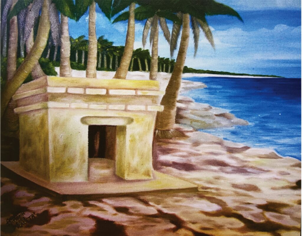
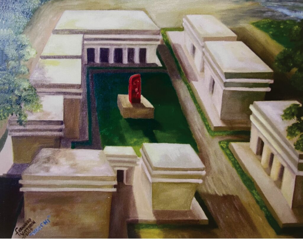
It is an isolated temple located on the coast built in direct relationship by inhabitants of Mulchi and La Caleta. To this temple arrived from nearby and remote places travelers that deposited vessels and effigies as leniency offerings dedicated to merchant and moon late period gods: Ek Chuah and Ixchel. Unfortunately this temple was destroyed by modern development without concerns for cultural heritage in the Riviera Maya after 1970.
Es un templo aislado ubicado en la costa pero con relación directa con los pobladores de Mulchi y La Caleta. A este templo llegaron pobladores cercanos y viajeros lejanos que depositaron vasijas y efigies como ofrendas benefactoras dedicadas a dioses tardíos del intercambio y de la luna: Ek Chuah e Ixchel. Desafortunadamente este templo fue destruido por el desarrollo inmobiliario y hotelero costero después de 1970.
Lela jump’éel k’úulnaj yaan nats’ ti’ le jal ja’oj ma’ nach yáanik ti’u káajnalilo’ob Mulchi’ mix ti’ le Caletailo’obo. Ti’ le k’u’ulnajá k’uch ya’ab máako’ob naats’u kaajalo’ob yéetel j-máako’ob ku xíimbalo’ob ku taasiko’ob p’úulo’ob yéetel u láak’ ba’alo’ob uti’al u síio’ob ti’ u k’u’o’ob le k’eexo yéetel le Eek’o’: Eek’ Chuah yéetel Ixchel. Ba’ale le k’u’ulnaja’ k’aaskunta’ab yo’olol e máaxo’ob tu beeto’ob najo’ob uti’al u p’aatal máako’ob, lele beeta’ab ts’o’ok u màan u ja’abil 1970.
Mulchi means “mouth of the mound”; it was built in the Postclassic period (1200-1500 A.D.). It contains a beautiful plaza with several temples surrounding a stela. During the conquest it was the head of the province of Belma, a town of 100 houses. A group of Spanish soldiers remained here two months to heal their wounds and were given two gold medals. This site was first explored in 1955 by researcher William Sanders, who noted banana plantations and a cenote near the site.
Mulchi significa “boca del montículo” y fue construido en el período postclásico (1200-1500 d.C.) y contiene una preciosa plaza que rodean una estela. En tiempos de la conquista era la cabecera de la provincia de Belma, un pueblo de 100 casas; un grupo de soldados españoles permanecieron aquí dos meses para curar sus heridas en donde también les obsequiaron dos monedas de oro. Este sitio se exploró por primera vez en 1955 por el investigador William Sanders quien notó sembradíos de platanales junto al sitio y un cenote.
Mulchi’ u k’áat u ya’al “u chi’ le múulo’” le la beetabo’ob tu ja’abilo’ob (1200 tak 1500 d.C.) yéetel yaan jump’éel jats’its kúuchil ku bak’pachtik. Tu k’iinilo’ob le tán le báatelo u jo’olil le u kaajil Belma yaanti’ mi 100 najo’obi’, jun múuch’ j-ba’atelob españaile p’ato’ob ka’ap’éel wi’nalo’ob uti’al u ts’akkuba’ob tu yáajilo’ob, tu ts’aob ka’ap’éel u taakinil oro. Le kúuchila yáax xíimbalta’ab ku k’aaba’tik William Sanders, leti’ e tu yilaj páak’a’an ya’ab ja’as náats’ ti’ le káajo bey xan náats ti’le ts’ono’oto.
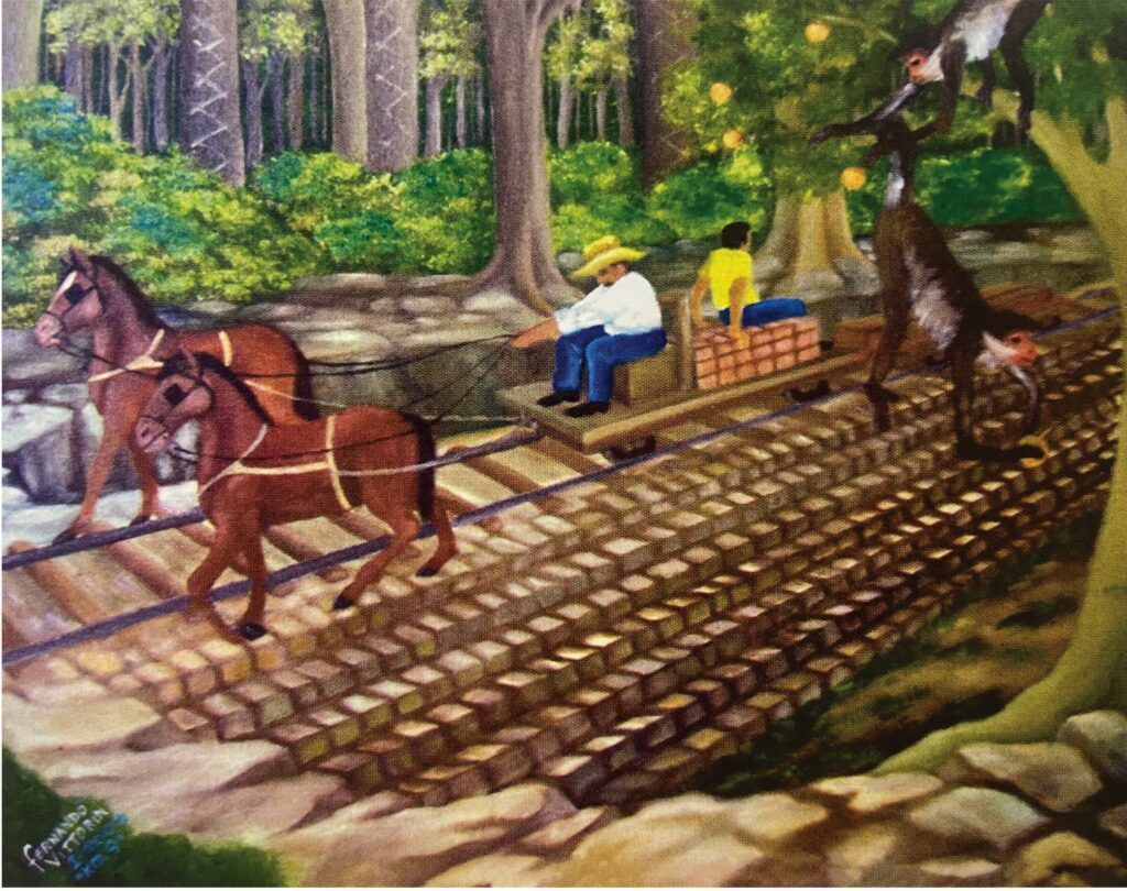
Puerto Morelos was also known as “Cork Point” due to a native tree named Annona glabra. Its bark is a type of cork that was utilized by modern and ancient Maya in the making of fishing nets. This tree produces an orange fruit that spider monkeys eat. At km 9 on the road to Central Vallarta you can admire an elevated stone road that was built during the chicle times. This road holds a metal rail with a flat wooden car and metal wheels pulled by horses that transported products for over 100 miles.
Puerto Morelos también era conocido como “Punta Corcho”. Este nombre se debe a un árbol nativo de nombre Annona glabra, el cual produce un fruto color naranja que le gusta a los monos araña de la selva, su corteza de tipo corcho que utilizaron los antiguos y los mayas modernos en la elaboración de redes de pesca. En el km 9 camino a Central Vallarta puedes admirar un camino elevado de piedra construido durante la época del chicle, donde se colocó un riel de metal con carros planos de madera y ruedas de metal que eran jalados por caballos que transportaron productos hasta Puerto Morelos por más de 120 kms.
Puerto Morelos k’aajota’an ka’ach bey “Punta Corcho”. E k’áaba’a ku tool ti’ jump’éel che’ ku k’aabatik Annona glabra, lela’ u yíiche bey cháak k’aane jach ki u jaantalo’ob tumen le maaxo’ob kaja’ano’ob ichil le k’aaxo’, u sóol le che’o meyajnaj ti le úuchilo’ob, ti’ le máayaao’ob meyajnaj utial u béetko’ob u k’aanil u chuk kaayo’ob. Ti le km 9 u beejil tak Central Vallarta. Je’el u páajtal uyila’al jump’eel beejil beeta’an yéetel tunich ka’anal elela beeta’ab tu k’iinil u jo’osal chicle, tu’ux beeta’an riel yéetel ku ku’ula’al tumen tsíimino’ob ku bisko’ob tak Puerto Morelos ku yáalkatiko’ob 120 kms.